|
A
view from above
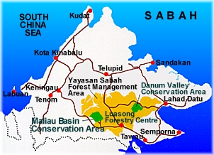
 Maliau Basin - Where is it? Maliau Basin - Where is it?
Maliau Basin Conservation Area is situated just above the
Equator in south central Sabah, the northernmost of the two
East Malaysian states on the island of Borneo.
Maliau Basin Conservation Area is adjacent to the
Yayasan
Sabah (Sabah Foundation) Concession Area, about 190 km from
the town of Tawau (on the southeast coast) and some 40 km
north of the Kalimantan (Indonesian) border at between 116ş
44' - 117° 3' E and 4° 41' - 4° 56' N.
Watch Maliau
Basin Video
You can watch
Maliau Basin, Sabah's Lost World Video Streaming from our
website. If you are using dial up modem connection, please
click on 56k link. If you are using ADSL/Broadband,
click on the 128k link.
 PLAY (56k Streaming)
|
PLAY (128k Streaming) PLAY (56k Streaming)
|
PLAY (128k Streaming)
|
|
Geographical Features
 The 588.4 km˛ (58,840 hectares) Maliau Basin Conservation
Area, encompasses the whole of Maliau Basin itself (390 km˛),
plus an additional 198.4 km˛ of forested land to the east and
north of the rim, including the fabled Lake Linumunsut, formed
by a landslide blocking a small tributary of the Pinangah
River. The 588.4 km˛ (58,840 hectares) Maliau Basin Conservation
Area, encompasses the whole of Maliau Basin itself (390 km˛),
plus an additional 198.4 km˛ of forested land to the east and
north of the rim, including the fabled Lake Linumunsut, formed
by a landslide blocking a small tributary of the Pinangah
River.
While all of this region is rugged, the saucer-shaped Maliau
Basin is distinguished by its almost circular perimeter,
sharply delimited on all sides by cliffs or very steep slopes,
making it insurmountable on foot from most directions. The
highest point is on the north rim, at over 1,675 m in elevation,
but has yet to be accurately surveyed. Resembling a volcanic
caldera, the 25 km diameter Basin is in fact a sedimentary
formation comprised mainly of gently inclined beds of
sandstone and mudstone.
The Basin represents a single catchment, and is drained by a
set of radiating tributaries of the Maliau River, one of which
descends a magnificent series of waterfalls, known as Maliau
Falls. Numerous smaller waterfalls have also been discovered
throughout the Basin. The Maliau River then drains through a
gorge out of the southeast of the Basin into the Kuamut River,
which in turn feeds into the Kinabatangan, the longest river
in Sabah.
|


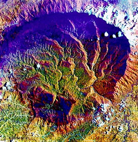 Satellite Picture Of Maliau Basin